Storm to watch in the next few days.

That wind is reported at flight level...does not mean it will reach the ground...
If we are talking about flight level wind being 140, then please forgive me.

I thought we were talking about surface winds.

There is, of course, significant gradient of wind velocity with respect to altitude.
 
In SE Charlotte. We have had some rain and a LOT of winds. I'm sure nothing like what others are seeing, but I don't recall it ever being these strong of winds in the 13 years I have lived here. You should have seen me dragging the dogs out this morning! LOL

Hope everyone is safe and dry!
 
In SE Charlotte. We have had some rain and a LOT of winds. I'm sure nothing like what others are seeing, but I don't recall it ever being these strong of winds in the 13 years I have lived here. You should have seen me dragging the dogs out this morning! LOL

Hope everyone is safe and dry!
That is what my son reports in the Greenville Spartanburg area, which isn’t too far away down 81

He has a number of trees down around his neighbors. Kid swingset broken up and destroyed. No electricity since 640 this morning power company sent out text messages saying Lauren electric at the time at 60,000 people without power and to expect multi day outage.
He’s been there I guess getting close to 10 years and never a source storm like this
 
Here on SC coast we got tornado warnings on the phone alert about 3:30AM. Power went out about 4:00AM

At about 7:30 I drove up the hill to get a cell signal. I assume the closest tower was on backup so I was left with no data - probably blocked off to ensure emergency services had it ? Anyway, checked Dominion site and our neighborhood and the one over were out of power with a few other outages as well. Our neighborhood is all underground but the feed is not and we loose power way too often.

Texted the boss and let him know. Drug the generator out of the garage and plugged in the fridges. Power came back on around 10:00AM.

Lots of power out in SC / GA.

Cedar key is a mess due to storm surge:

 
^^ Nice update. Rough going for many people. Hazards of coastal living.
I am surprised or better said impressed on how the newer homes held up. The key is they are built much higher do to new FEMA requirements. Being they look as good as shape they are in considering the magnitude of the storm, it looks like to me this is much more tidal water damage then wind. Of course not to say the wind was not severe. I just expected to see more damage to the new homes.
 
Upstate of South Carolina, got it pretty good, not as a hurricane, but a strong tropical storm.
My son has many trees down, kids outdoor play center has been torn down, even the furniture on his deck has been pushed to one corner and his mailbox knocked down.
Electric company says it could be days before power restored

But this topped it off, he just sent me this alert that showed up on his cell phone.
The 911 system is down in Spartanburg County 🤨

IMG_0095.webp


Pretty scary, as much as I love the south, they can’t spell worth a darn.
They spelled indefinite wrong!!!!
 
Last edited:
Atlanta was essentially a non-event. Areas which are prone to flooding, end up flooding, areas which are not are fine. My mother in WNC was fine although the roads were closed due to flooding, but those road flood during bad rain T-storms.

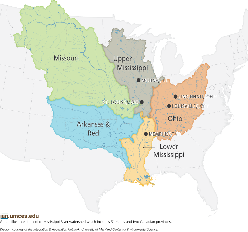
Asheville and west are going to get it bad though. Louisiana is in trouble because the watershed of the Mississippi river.

mississippi-river-watershed-map.png
 
Last edited:
I'm not far from the three rivers. where the red, Mississippi, and Atchafalaya converge. i have a bayou behind my house that feeds the red river, so it will start backing up shortly. our camp is on the red and anytime it gets high we have water in the woods, which mean roads get bad quickly.
 
If we are talking about flight level wind being 140, then please forgive me.

I thought we were talking about surface winds.

There is, of course, significant gradient of wind velocity with respect to altitude.
That 140 mph wind put in the NHC was not at flight level wind speed. They are estimated it and use mathematical formulas to estimate the surface wind speed.

Quite a write up about that after Hurricane Micheal by the way… Very interesting to read all of that.

Like you said it’s at 10 meters… Which during Hurricane Isabel in 2003 a peak wind gust of 99 mph was recorded at Gloucester Point … At 67 feet I believe. Obviously almost double that 10 meter height. . Though a 109 mph gust was measured at the ground near Gwynn’s Island in Mathews county…

I am rather sure you know this has well.. The Hurricane Hunter aircraft uses dropsondes which give wind speed, barometric pressure, humidity etc as it falls to the ocean’s surface. Those can be used if it just happens to fall in the best area of the eyeball to estimate highest wind speeds has well.
 
Last edited:
Back
Top Bottom