What would you recommend for a DIY HO'er to use to record a simple topo grid in an area of say 75' x 38', for drainage purposes? (Nothing legal)
I'm exploring drainage options (regrade, install perforated pipe/then solid to daylight, dig 4' x 6' hole/well and install a flow-well, etc). Drainage needs to be corrected both parallel to concrete foundation on this side as well as perpendicular.
The low corner of the foundation is about 4" above the soil, right at a 90° corner. I need to drain this low spot to the front. I'm hoping for 1"/8' but might only get 1"/16'.
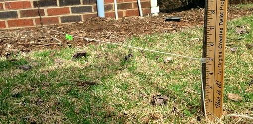
What I've done is establish a level line 68' long and make meas. every 4'. Total drop = 14"/68', but it goes up and down a few inches over a large tree root, rock walk, etc. I had to open a gate to go this distance.
Looking for something one guy can do. Have considered a water level on a yardstick and marking out a grid using sprinkler flags. I could go around corners like this as well. I'll draw it out to scale in either SketchUp or AutoCad.
How do you pro's do this? Grid size?
I'm exploring drainage options (regrade, install perforated pipe/then solid to daylight, dig 4' x 6' hole/well and install a flow-well, etc). Drainage needs to be corrected both parallel to concrete foundation on this side as well as perpendicular.
The low corner of the foundation is about 4" above the soil, right at a 90° corner. I need to drain this low spot to the front. I'm hoping for 1"/8' but might only get 1"/16'.
What I've done is establish a level line 68' long and make meas. every 4'. Total drop = 14"/68', but it goes up and down a few inches over a large tree root, rock walk, etc. I had to open a gate to go this distance.
Looking for something one guy can do. Have considered a water level on a yardstick and marking out a grid using sprinkler flags. I could go around corners like this as well. I'll draw it out to scale in either SketchUp or AutoCad.
How do you pro's do this? Grid size?