I know nothing about weather - will the storm on the west coast cause these storms to track into the SE US because of the low pressure?
You are using an out of date browser. It may not display this or other websites correctly.
You should upgrade or use an alternative browser.
You should upgrade or use an alternative browser.
Possible Hurricane Forming in Atlantic (70% Chance), Track Unknown at this Time
- Thread starter 97K15004WD
- Start date
- Joined
- Jun 8, 2022
- Messages
- 5,661
There will be 15 to 20 named storms in the Atlantic this year. This one may not even form, and if it does it may blow out to sea.
The best place to get Atlantic Hurricane Weather - when they do come along - is Levi's blog. He has been spot on for quite a few years. Also, he is not one of the youtube hypsters - he puts up the maps, explains them, goes through some probabilities. Excellent education for those interested.
 www.tropicaltidbits.com
The best place to get Atlantic Hurricane Weather - when they do come along - is Levi's blog. He has been spot on for quite a few years. Also, he is not one of the youtube hypsters - he puts up the maps, explains them, goes through some probabilities. Excellent education for those interested.
Tropical Tidbits
Tropical weather and Atlantic hurricane information, analysis, and forecasts by Levi Cowan.
www.tropicaltidbits.com
JHZR2
Staff member
Did you read the weather outlook text?
I know nothing about weather - will the storm on the west coast cause these storms to track into the SE US because of the low pressure?
Doesn’t seem like right now these have much of a chance other than one of them bringing heavy rain to that Caribbean (much needed right now).
I know nothing about weather - will the storm on the west coast cause these storms to track into the SE US because of the low pressure?
Ahh no.
Storms in the western Atlantic are moved by upper level winds that are both oceanic and land driven. The westerlies are the upper level winds that go from west to east and typically push hurricanes north than northeast. Cold front passages from west to east are a huge factor in tracks seen.
Bermuda High pressure locate east of the US coastline can push hurricanes south towards Florida or west far enough to hit the southeast US coast. The Antilles and Caribbean are the defining region where the hurricanes either track north or south of the Caribbean. North of the Caribbean Florida and the southeast US maybe in play and south of the Caribbean then Mexico and the Gulf of Mexico states are in play. And if there is a cold front approaching from the west and a strong Bermuda high pressure in place then the hurricane can travel between the two and come up the east coast then recurve northeast from there.
A rare occurrence is when a very strong high pressure builds off the Nova Scotia and Newfoundland region and builds down south and southwest along the US coastline…. Hurricane Isabel did that in 2003 along with Hurricane Hugo in 1989 and Superstorm Sandy in 2012.
I looked at the latest upper air forecast related to the North Atlantic Oscillation and it is turning a bit more negative in the next 6-10 days. Which makes sense given the GFS forecast model continues to show cold fronts moving regularly eastward and pushing off the east US coast.
With that pattern happening then it should push the storms sharply north and then northeast away from the US coastline. I feel fairly confident that the US east coast should be shielded from any approaching storms due to that upper air pattern. The Caribbean is in play. Which means the Gulf of Mexico and US states along that are in play too. A fascinating look and reading the history of Hurricane Harvey is worth a look at. Quite a journey there and the rapid deepening of that storm in the southwest Gulf was really something.
However a lot can change … even in 6-10 days out in time. Weather is a lot like fishing… that’s why it’s not called catching… Weather is the same way once you go beyond 6 days when it comes to very detailed forecasting.
Last edited:
97K15004WD
Thread starter
Yep. I'm looking at macro weather events, not the localized forecast.Did you read the weather outlook text?
Doesn’t seem like right now these have much of a chance other than one of them bringing heavy rain to that Caribbean (much needed right now).
As I said, I'm no meteorologist, so I'm wondering on a "macro" scale how the low pressure on the west coast influences the east coast weather as Hilary moves the air in the upper atmosphere towards the west coast.
97K15004WD
Thread starter
... A rare occurrence is when a very strong high pressure builds off the Nova Scotia and Newfoundland region and builds down south and southwest along the US coastline…. Hurricane Isabel did that in 2003 along with Hurricane Hugo in 1989 and Superstorm Sandy in 2012.
Great info in your whole post, thank you for that!!
Okay, that's what I was wondering as I remembered something unusual about Hugo back in 1989 !
I remember the forecaster's predicting issues one way or the other depending on the high altitude winds - couldn't remember exactly what that was all about. When I was working during the storm, the EOC had a very detailed weather forecast that was sometimes updated hourly, IIRC. We planned resources on the expected landfall areas. The upper "steering winds" were the biggest concerns affecting the landfall. Turns out it was so big and forceful, it almost didn't matter at the state level for us. Devastation was everywhere along the coast and inland too.
Since that was over 30 years ago, I wondered if more information was available now. At the time, they were looking at satellite imagery on different wavelengths and flying at different altitudes around the storm and into the storm dropping sensors.
Last edited:
- Joined
- Jun 8, 2022
- Messages
- 5,661
That question is way to complex for this board, however very generally, a storm blows off Southwest Africa and may form, being pushed by the westerly equatorial winds towards North and Central America. If it does form a rotational storm, and thats a big if, then it encounters steering forces as it approaches, which are mainly high pressure fronts (which steer it away) and low pressure - which pulls it towards.Yep. I'm looking at macro weather events, not the localized forecast.
As I said, I'm no meteorologist, so I'm wondering on a "macro" scale how the low pressure on the west coast influences the east coast weather as Hilary moves the air in the upper atmosphere towards the west coast.
If the jet stream is lower in N. America at the time that will push the storm either South - into the gulf, or North, towards the open Atlantic or Bermuda. If it does enter the gulf, then where it travels has more to do with local weather forces - such as easterly winds coming from the West, like from the Pacific side of Central America. This all assumes that these winds don't create shearing forces, - which are upper level winds blowing in a different direction than storm is travelling, blowing the top off the storm ruining its rotation, and weakening or completely ending it. Hurricanes get their strength by pulling warm air from the ocean surface up into the storm via their rotation. Incomplete rotation and the storm quickly falls apart.
Levi (I posted his blog above) does a really good job of explaining all this, and hopefully he will again this year. In previous years he would drop a new vlog daily about any storms that form - and he educates you on all these forces with images and things that make it easy to understand.
97K15004WD
Thread starter
...Levi (I posted his blog above) does a really good job of explaining all this, and hopefully he will again this year. In previous years he would drop a new vlog daily about any storms that form - and he educates you on all these forces with images and things that make it easy to understand...
Thank you for that link; I looked at that earlier and the models went right over my head. I intend to "study up" on it though, and that looks like an excellent resource!
JHZR2
Staff member
Yes, I get it and it’s a good question you have. The reason why I brought up their write ups is because in there they give a percentage of likelihood of formation over different timelines, and some more regular language about if they think it’s going to be of concern and why…Yep. I'm looking at macro weather events, not the localized forecast.
As I said, I'm no meteorologist, so I'm wondering on a "macro" scale how the low pressure on the west coast influences the east coast weather as Hilary moves the air in the upper atmosphere towards the west coast.
- Joined
- Jun 8, 2022
- Messages
- 5,661
Forget the charts. Those are hard for meteorologists to digest. Watch his videos. He just dropped a current one. There isn't much to see because the storms are new and far out to sea, but he covers the Atlantic storms starting at about 8:00 minutes in. When you get a big storm closer to land, he goes into far more detail.Thank you for that link; I looked at that earlier and the models went right over my head. I intend to "study up" on it though, and that looks like an excellent resource!
Tropical Tidbits
Tropical weather and Atlantic hurricane information, analysis, and forecasts by Levi Cowan.
www.tropicaltidbits.com
As a retired weatherman from the NWS I must say that this site Mikes Weather Page is a good site for tropical weather...He uses and posts all of the text products from the NHC...
I think he is a weatherman in his own right, having gone to school with a niece of mine in Savannah. His blogs add a little more explanation (at times) than the NHC does.As a retired weatherman from the NWS I must say that this site Mikes Weather Page is a good site for tropical weather...He uses and posts all of the text products from the NHC...
Yes, I get it and it’s a good question you have. The reason why I brought up their write ups is because in there they give a percentage of likelihood of formation over different timelines, and some more regular language about if they think it’s going to be of concern and why…
It doesn’t affect much 3 or 4 or 5 thousand of miles to the east in this case…. Practically zero in fact… If we are referencing the vast majority of the western Atlantic….
Now if there was a storm that n the far western Gulf of Mexico… then it could have an effect.
I have always noted it was about 2-3 thousand miles when say an upper level trough and attending cold front would just barely start to affect a hurricane path approaching the US east coast. Say when a cold front is in the upper Midwest of the US. And by the time that front gets to the Ohio valley then it really has a stronger affect, And this is in a circumstance where the hurricane is off the coast of South Carolina.
Fun fact for this discussion…. Fastest hurricane forward movement is thought to be the Long Island Express Hurricane of 1938… Estimated forward speed is thought to have reached nearly 60 MPH north forward speed. It was squeezed between a very strong Bermuda high pressure center and a very strong approaching cold front and upper level jet stream from the west. And once the storm got north of Hatteras it went from less than 5 mph and accelerated to 60 mph by the time it hit Long Island.
Last edited:
JHZR2
Staff member
I’d tend to agree. And this goes into the thinking and language that the nhc uses when writing those reports.It doesn’t affect much thousands of miles to the east in this case…. Practically zero in fact… If we are referencing the vast majority of the western Atlantic….
Now if there was a storm that n the far western Gulf of Mexico… then it could have an effect.
There have been decent changes since last night.
I'm disappointed we haven't had one pass through here yet this year. There's a family here who recently moved down from Wisconsin. They have no concept of what a hurricane is. Last year, we had a tropical storm coming up from the gulf that made landfall in the Florida panhandle, and these people went into full fledged panic. It was a sub-tropical low by the time it even got to us, all of 30 mph winds, but they boarded the house and took off to family in Wisconsin. The power didn't even go out. We got like 2" of rain and a few gusts of wind. We've had summer popup storms that were far worse.
I've always been fascinated by hurricanes and tornadoes. I rode out Katrina (2005) which took half of our roof and collapsed the hayloft of the barn. We had 5 or 6 trees down across our driveway and power was out for over 3 weeks. My dad, a type 1 diabetic, kept his insulin in a water tight container tied to a 20 oz coke bottle full of cement. He would sink it to the bottom of our pond (~20 ft deep) to keep it cool, using an empty milk jug as a cork to locate and retrieve it.
I've always been fascinated by hurricanes and tornadoes. I rode out Katrina (2005) which took half of our roof and collapsed the hayloft of the barn. We had 5 or 6 trees down across our driveway and power was out for over 3 weeks. My dad, a type 1 diabetic, kept his insulin in a water tight container tied to a 20 oz coke bottle full of cement. He would sink it to the bottom of our pond (~20 ft deep) to keep it cool, using an empty milk jug as a cork to locate and retrieve it.
Last edited:
He has a degree in marketing and none in meteorology...He is just nuts about weather and does a good job on his page...I think he is a weatherman in his own right, having gone to school with a niece of mine in Savannah. His blogs add a little more explanation (at times) than the NHC does.
I’d tend to agree. And this goes into the thinking and language that the nhc uses when writing those reports.
There have been decent changes since last night.
View attachment 173986
Yes sir true indeed…
One thing of note here… my area has n southeast Va is supposed to be quite cool Wednesday with a high temp in the low 80s. A cold front passing in the region. If it is a northeast front direction moving south and southeast from Nova Scotia and Newfoundland….
That would be interesting to see where it steers the storms. .
Im going to check the GFS models to see what’s the trend here,
Don't wish for something to cause destructions to others homes and livelihoods here in Houston even if i always come out unaffected since I've always got lucky land wise. But i would love some rain as it's getting dire. Can't remember when it last rained.
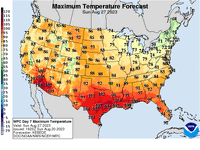
Here’s the current day 7 forecast for high temperatures… If this turns out then it is indicative of a strong cold front that has pushed off the east coast. Which also correlates with a negative trending North Atlantic Oscillation pattern that the GFS forecast models are predicting 7 days out.
The question remains about the one in the Caribbean and how and it moves in the next 3-5 days. It could get in between a west approaching upper level trough and accompanied frontal system and an area of high pressure to the east which would create a path that could make it closer for the southeast US.
Right now the GFS has it pushed northeast by days 3, 4 and 5. But then it has it turning northwestward due to a blocking high pressure to its north and sending that storm in to Maine of all places. That all in the days 7-10 time frame.
Which I say again… it’s like fishing at that point. And not called catching. Not a lot of confidence in a day 7-10 hurricane forecast track.
Attachments
Similar threads
- Replies
- 79
- Views
- 3K
- Replies
- 221
- Views
- 59K
- Replies
- 37
- Views
- 5K
- Replies
- 26
- Views
- 5K