Need advice for a trip to Sarasota (right on time for a hurricane)

Owen Lucas

$100 Site Donor 2023
Joined
Sep 5, 2021
Messages
2,581
Well, it's been a rough summer and my wife and I are in need of some serious beach relaxation. We are due to arrive in Sarasota on Sunday 8-27 and leaving 9-1.

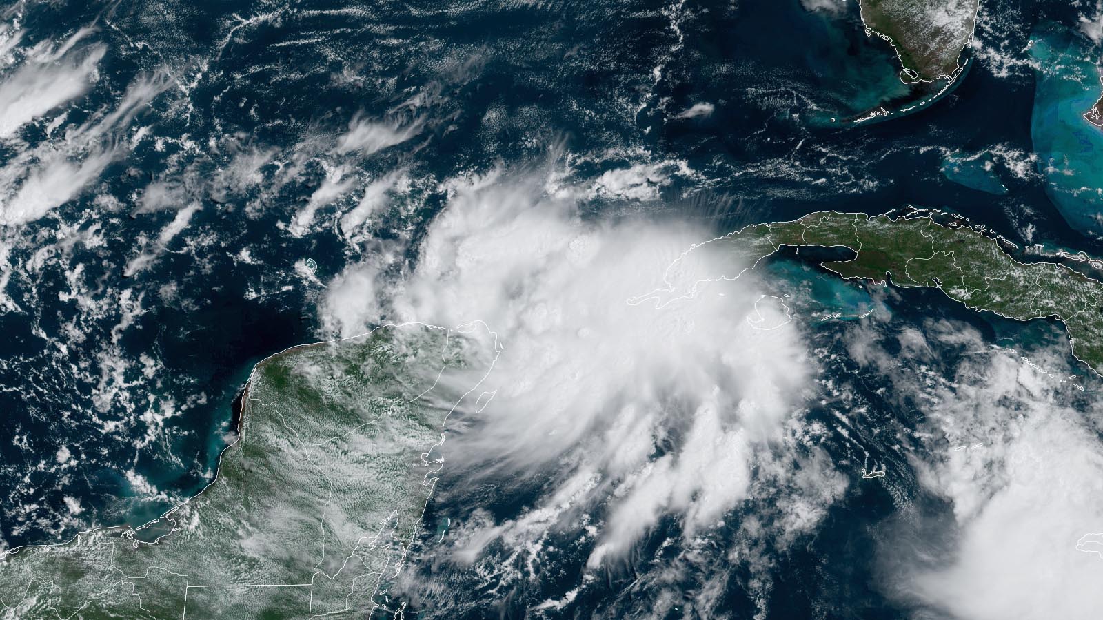
Of course there is a tropical depression with the potential to be a category 1 hurricane coming right at the gulf. The outer edge of the lowest predicted track looks like it will glance Sarasota.

I've been told that category 1 hurricanes are just another day in Florida and the people don't even evacuate for these. I don't know how that translates to trying to catch some rays on the beach.

If the hurricane lands up by Panama City, should I still expect dangerous surf and winds 300+ miles south in Sarasota? If we decide not to cancel, would a Gulf coast hurricane cause issues on the Atlantic side if we drive across the state?

Map of Invest 93-L


Map of Invest 93-L
 
Keep an eye on it at https://www.nhc.noaa.gov/refresh/graphics_at5+shtml/234234.shtml?cone#contents

You can also watch Levi's blog, but he will refer you back too the NHC as well. https://www.tropicaltidbits.com/

Your still 72 hours out. The accuracy of these forecasts beyond 48 hours is pretty rough, and if you recall the big one last fall they only got like 23 hours notice.

Flying or driving? Can you delay a bit? The best weather you will get is after a tropical storm passes - it takes all the energy and humidity with it.

1693096958218.jpg
 
Nuch to early to worry. Have not yet published a projected track.
Cat 1 is serious. If it hits you direct. If center misses you by 30 to 50 miles, not quite as bad. Twenty years ago, Hurricane caused a lot of damage in Orlando but no damage here in Mt. Dora, 25 miles away.

As for surf, even a little storm over the gulf will cause heavy surf.

Don’t believe the Talking Heads as they are only correct within 24 hours before storm hits.

Take your trip and enjoy.
 
Flying or driving? Can you delay a bit? The best weather you will get is after a tropical storm passes - it takes all the energy and humidity with it.
Thank you for the forecast cone.

We are flying into Bradenton. Rental car at the airport then 30 mins down to Siesta Key. I'm thinking Sunday and Monday we relax and decide Tuesday AM if we drive across to the Atlantic side or south for a day.

The best weather you will get is after a tropical storm passes - it takes all the energy and humidity with it.
Good to know!

As for surf, even a little storm over the gulf will cause heavy surf.
I'm not much of a swimmer, just being on the beach is enough for me.
 
I live in Jupiter, FL on the East Coast. A couple of thoughts. I don't believe anybody's predictions. I use various radar and weather apps to judge for myself. The idea that a true Cat 1 storm is a minor event, is very misleading. Even a TRUE tropical storm is akin to the strong 50 or 65MPH wind gusts and microburst associated with a major thunderstorm, just that it doesn't end for 12 hours, very unpleasant. An actual hurricane is with 70+ MPH sustained winds, is damaging and very uncomfortable.

However, let's be very honest about weather forecasting lately. They sensationalize. They call storms hurricanes, that clearly are not. When I see the wind vectors at 35Kts, and peak wind gusts at the airport of 45Kts, I know. On the other hand, the water temperature in the Gulf is at it's peak right now, and that drives intensity. Storms can go from a Cat 1 to a Cat 4 in a blink of an eye.

Also, airline travel prior to, and after a real storm is generally quite smooth between the outer bands of rain. We fly all of our planes out early, and I'm always amazed at how stable the air can be.

Consider the NASA visitors center on the East coast, as a possible destination, if you've not done that. Make sure to see the Saturn V and the Shuttle.
 
So I took a look at the winds aloft, 3000 feet, the center of circulation is near Cancun, Mex, with a 10 to 20Kt speed, lower at sea level. Really meaningless at the moment, other than to say, it's nothing yet. Winds at Cancun airport are currently 3Kts, and forecast 6Kts, increasing to 15Kts within the next 24 hours.

As I mentioned, I like to watch the actual conditions and not what the forecasters predict.
 
I live in Jupiter, FL on the East Coast. A couple of thoughts. I don't believe anybody's predictions. I use various radar and weather apps to judge for myself. The idea that a true Cat 1 storm is a minor event, is very misleading. Even a TRUE tropical storm is akin to the strong 50 or 65MPH wind gusts and microburst associated with a major thunderstorm, just that it doesn't end for 12 hours, very unpleasant. An actual hurricane is with 70+ MPH sustained winds, is damaging and very uncomfortable.

However, let's be very honest about weather forecasting lately. They sensationalize. They call storms hurricanes, that clearly are not. When I see the wind vectors at 35Kts, and peak wind gusts at the airport of 45Kts, I know. On the other hand, the water temperature in the Gulf is at it's peak right now, and that drives intensity. Storms can go from a Cat 1 to a Cat 4 in a blink of an eye.

Also, airline travel prior to, and after a real storm is generally quite smooth between the outer bands of rain. We fly all of our planes out early, and I'm always amazed at how stable the air can be.

Consider the NASA visitors center on the East coast, as a possible destination, if you've not done that. Make sure to see the Saturn V and the Shuttle.
I appreciate the input as a Floridian @Cujet. I agree it is hard to tell what is going on regarding weather forecasting, everything is sensationalized now, MSM is dying for ratings.

I'd rather not be in the area with the conditions of a tropical storm or Cat 1, especially since we are staying 300 ft. from the beach.

Thank you for the advice on the NASA visitors center, I'll keep it in mind if we go east.
 
I've been through many hurricanes here in eastern NC. They are a worry when your property is in jeopordy. I imagine if you are a tourist and have nothing to lose, except your rental car it can be a thrilling experience.

Nothing can focus your attention like 90 mph winds screaming like a banshee and palm trees bent over 45 degrees.
🌴 🌴
Years ago - before Katrina - I sat out a I believe a CAT2 in New Orleans on what was a planned business trip. I was right off Bourbon street in one of the big Hotels - Marriott maybe? The Hotel left a letter under that door saying all but essential staff had been sent home and there would be no services or food, but the bar would in fact remain open.

It came and went - by the time it got through the Delta is had weakened a bunch. I think we lost power briefly but not for long.

A few years later when Katrina hit I realized how lucky I had been, and that the water was the problem, not so much the winds.
 
The cone of uncertainty, seems to make some people outside that cone, think that there will be little to no effects. Ive heard two people dismiss it entirely, one base on spagetti models their phone fed them, with data 12 hours old.

Levi states how this storm developed a defined center of circulation well before any of the models predicted it would.
The NHC says:
"User are reminded that there is significant uncertainty in 3-4 day
intensity predictions and are urged to monitor changes to future
forecasts."

I'm hoping we get a few inches of rain.

It's basicaLly 3.5 hours to get to Atlantic from Sarasota area.

Atlantic will have strong Ssw winds, but nowhere nead as strong as winds on gulfside are likely to be.
Going south towards Marco Island might get one sunny and windy onshores severaL hours before Englewood and north does.

I know an old Florida cracker who strongly believe there is a magnet in Myakka river valley that sucks northward boundstorms into it

I'm a bit excited for it, which might mean it turns into a nothingburger.

But it will likely be the "I" storm and these have been consequential.
 
They haven't even flown through it or dropped their sensors in. They really don't know anything at this point.

Not to mention their models past 48 hours are more a guess.

If it sits and picks up steam, it could be a thing.

If the dry air from the west gets pushed in, it could turn into a decent thunderstorm and that's it. Most of the time that is what happens, which is why it always seems people that live on the coast - like me - get complacent.

Tropical Storms are nothing to mess with, but there are a dozen a year and most do nothing or go someplace else. You can't plan around them, just be prepared to get out of Dodge if needed.
 
Having a house in Sarasota, I avoid going down between May and September just because of the humidity. I guess just for a few days it's tolerable.

I think I might have to upgrade from the convertible we have reserved!
Only the tourists drive convertibles in the summer or during daylight. It's not just the heat, and it's not just the humidity. It's also the greater intensity of the sun.
 
Only the tourists drive convertibles in the summer or during daylight. It's not just the heat, and it's not just the humidity. It's also the greater intensity of the sun.
Yep. I grew up on the plains. Always thought a convertible would be cool. I now live somewhere that I realistically could use with the top down most of the year if I wanted but have zero interest - too hot, too sticky, too many bugs.
 
Only the tourists drive convertibles in the summer or during daylight. It's not just the heat, and it's not just the humidity. It's also the greater intensity of the sun.
Good point, I might just upgrade to an SUV then. I have a feeling there will be a wide selection of rentals available.
 
i always get annoyed when there is 8 hours between official updaTes.


At the very bottom of these 'eye of the storm' updates, there is a blog, and some of the posters are knowledgeable, weather nerd enthusiasts and post interesting and useful satellite pics and compare model updates.

But like any forum nowadays , much which is written is just polarized half witted opinions, and wishcasting.
 
Only the tourists drive convertibles in the summer or during daylight. It's not just the heat, and it's not just the humidity. It's also the greater intensity of the sun.
That's not really so. I drive my Jag convertible with the top down all the time. It is quite nice to drive to the beach with the top down and the AC on. Hat and sunglasses required.
 
Back
Top