It´s like the US version of SeaLand, some old radar platform that can only be accessed by helicopter. People used to shoot off fireworks there and it was talked about turning into a ocean bed and breakfast. It´s not the Texas Tower(s) something similar, I think it´s outside of 7 miles from the coast.
You are using an out of date browser. It may not display this or other websites correctly.
You should upgrade or use an alternative browser.
You should upgrade or use an alternative browser.
What is that place called off shore of New York in the Atlantic?
- Thread starter Vern_in_IL
- Start date
Greenland.
I'm pretty sure it's Texas Tower 4. Its remains are at the bottom of the Atlantic. It's 60 miles out to sea.
Vern_in_IL
Thread starter
I think I´m looking for Frying Pan Shoals Light Tower. Down by SC, it seems to be the only suitable structure that would compare to Sealand. Anything else has been destroyed.

Hog Island (New York) - Wikipedia
Yeah, Im confused, OP needs to provide more information.So we're not talking about Long Island?
@Vern_in_IL
I was thinking he was talking about the Ambroise Light Tower 10 ish miles outside of NY Harbor.
(edit) I dont think the OP is talking about this one, at least in the sense that it would never become a bed and breakfast.
We lived on the South Shore of Long Island and would exit the bay through Jones Inlet, head over to the tower for blue fishing and from there to the coast of New Jersey called the "Highlands"
The tower had a lot of instruments on it as well as radio beacons ... It was large, included an area for employees to exit a boat and climb up to the tower.
It directed the huge freighter traffic into NY Harbor. It was also a NOAA weather station and you could get wave heights and wind speeds from it.
We used that information frequently because even as teenagers at the time we had Small 18 to 20 foot runabouts and would head out into the Ocean Fishing, start out at sunrise while the water was calm.
Casting jigs around the tower was a surefire way to catch good size bluefish and as weather conditions permitted we would also head over to the New Jersey coast called the "Highlands" then from there at times the Cholera Banks which was south of Jones Beach. By 12 noon we would in most cases have to start heading in as the afternoon winds start picking up.
Kind of interesting, we did all this traveling about in the ocean, with no land in site using nothing but a compass and charts. No electronic aids, no GPS, cell phones did not exist, communication was marine radio for an emergency or contacting others. The marine radio did have the capability to call the NY Marine Operator who would place and connect you to a landline for calls. It wasnt a fast process though.
It really was a cool feeling, no land in site and nothing but ocean, at times your mind says you should be going the opposite way that the compass was telling you, you always followed the compass *LOL* sure enough at some point you would see the beaches of Long Island as you headed home. Though sometimes it was an hour or more before you did.
You also paid attention to the position of the sun, it was an automatic "thing" in case your compass ever for some reason broke, you could reasonably figure out which way was land. I think at some point I got a pocket compass as a back up.
Looking at the information below I didnt even know it was rebuilt. The Ambrose we fished around was the one in the photo that was built in 1967 (with the helicopter pad on it)
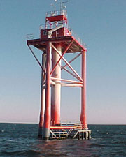
Ambrose Light - Wikipedia
Last edited:
- Joined
- Nov 29, 2021
- Messages
- 5,387
New EnglandIt´s like the US version of SeaLand, some old radar platform that can only be accessed by helicopter. People used to shoot off fireworks there and it was talked about turning into a ocean bed and breakfast. It´s not the Texas Tower(s) something similar, I think it´s outside of 7 miles from the coast.
Honorable mentions: Long Island, Staten Island (the original NYC garbage dump IIRC)
twouvakind
Site Donor 2024
Neat tale, the only cruising I did in LI as a youth was by expressway to see Twisted Sister at Hammerheads. Long retired lightship that was replaced by the tower at South Street Seaport Museum.Yeah, Im confused, OP needs to provide more information.
@Vern_in_IL
I was thinking he was talking about the Ambroise Light Tower 10 ish miles outside of NY Harbor.
(edit) I dont think the OP is talking about this one, at least in the sense that it would never become a bed and breakfast.
We lived on the South Shore of Long Island and would exit the bay through Jones Inlet, head over to the tower for blue fishing and from there to the coast of New Jersey called the "Highlands"
The tower had a lot of instruments on it as well as radio beacons ... It was large, included an area for employees to exit a boat and climb up to the tower.
It directed the huge freighter traffic into NY Harbor. It was also a NOAA weather station and you could get wave heights and wind speeds from it.
We used that information frequently because even as teenagers at the time we had Small 18 to 20 foot runabouts and would head out into the Ocean Fishing, start out at sunrise while the water was calm.
Casting jigs around the tower was a surefire way to catch good size bluefish and as weather conditions permitted we would also head over to the New Jersey coast called the "Highlands" then from there at times the Cholera Banks which was south of Jones Beach. By 12 noon we would in most cases have to start heading in as the afternoon winds start picking up.
Kind of interesting, we did all this traveling about in the ocean, with no land in site using nothing but a compass and charts. No electronic aids, no GPS, cell phones did not exist, communication was marine radio for an emergency or contacting others. The marine radio did have the capability to call the NY Marine Operator who would place and connect you to a landline for calls. It wasnt a fast process though.
It really was a cool feeling, no land in site and nothing but ocean, at times your mind says you should be going the opposite way that the compass was telling you, you always followed the compass *LOL* sure enough at some point you would see the beaches of Long Island as you headed home. Though sometimes it was an hour or more before you did.
You also paid attention to the position of the sun, it was an automatic "thing" in case your compass ever for some reason broke, you could reasonably figure out which way was land. I think at some point I got a pocket compass as a back up.
Looking at the information below I didnt even know it was rebuilt. The Ambrose we fished around was the one in the photo that was built in 1967 (with the helicopter pad on it)
Ambrose Light - Wikipedia
en.wikipedia.org
OMG I remember the Hammerheads name so well but not sure if I was there or it was just the advertising all the time, if I was it wasnt often that I remember.Neat tale, the only cruising I did in LI as a youth was by expressway to see Twisted Sister at Hammerheads. Long retired lightship that was replaced by the tower at South Street Seaport Museum.
OBI (Oak Beach Inn) was a place we liked a lot and Tabard Ale House in Wantagh... as well as local places. ( I cant remember the names anymore *LOL*) Oak Beach Inn and Tabard Ale house were the bigger/more well known ones we hung out.
I have a relative who even recently has photos she posts with Dee Snider. She was a big fan to say the least.
Man, I think back, the world has changed so much since then, hanging out with close friends all the time, in real life, not electronic means and texts.
Similar threads
- Replies
- 5
- Views
- 3K
- Replies
- 21
- Views
- 6K