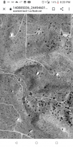
Someone on FB posted some old Arial photos. I was able to find my house when it was just a homestead cabin. No power poles so no power yet. It is the one closest to the center of the shot. I also own the one just to the right of my place.
You are using an out of date browser. It may not display this or other websites correctly.
You should upgrade or use an alternative browser.
You should upgrade or use an alternative browser.
My house. 1959
- Thread starter Chris142
- Start date
Chris142
Thread starter
That's amazing.
Who would have been taking aerial pics of such a remote location back then, and why? Oil and gas?
Who would have been taking aerial pics of such a remote location back then, and why? Oil and gas?
Nice little slice you have carved out there. Very cool to see the old vs current.
That is possible, could also be military... My father in law used to develop and organize the aerial shots that pilots took while he was in USAF down in Texas.That's amazing.
Who would have been taking aerial pics of such a remote location back then, and why? Oil and gas?
I suppose it could have just been land developers.Nice little slice you have carved out there. Very cool to see the old vs current.
That is possible, could also be military... My father in law used to develop and organize the aerial shots that pilots took while he was in USAF down in Texas.
You know...trying to find the next "Sun City".
")
AutoMechanic
Site Donor 2024
Very cool.
gathermewool
Site Donor 2023
I'll have to stop by for directions some time...
Our county assessor has aerials from each decade roughly.
Here’s my lot in 1937 and 2018 while still under construction. There was an orchard or something at the top of the photo and the lake hadn’t dug/dam built yet.


Here’s my lot in 1937 and 2018 while still under construction. There was an orchard or something at the top of the photo and the lake hadn’t dug/dam built yet.
Chris142
Is there ever any water in the river or wadi, by your home?
Is there ever any water in the river or wadi, by your home?
Chris142
Thread starter
Yes.the Mojave river is 1m west of me. It is one of 2 rivers that flow backwards so I am told. The mojave is usually dry but does flood when it rains.Chris142
Is there ever any water in the river or wadi, by your home?
that's 1 mi right? not 1 meter.... esp in the top "old" photo, it looks like the area from the last crook in the road to your "driveway" runs through a dry channel-like Depression...Yes.the Mojave river is 1m west of me. It is one of 2 rivers that flow backwards so I am told. The mojave is usually dry but does flood when it rains.
Chris142
Thread starter
Ya 1 mile. There is a small gully just north of me.no water in it but trees live there and I do not water them. There is a large gully south of me that has had water flowing in it when it rains a lot. This is also the gully that is supposed to have Gold in it.that's 1 mi right? not 1 meter.... esp in the top "old" photo, it looks like the area from the last crook in the road to your "driveway" runs through a dry channel-like Depression...
I dunno if I have and pics but I will look.
Chris142
Thread starter
Someone from Hesperia posted a pic of a rainbow right at my house. You can see the large gully on the right.you can also make out the small one going left to right and it drops into the bigger gully. Mu house is k;nda on a triangle between the 2 gullys.
Attachments

Chris142
Thread starter
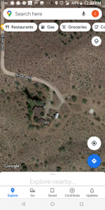
If you guys are looking for aerial views of your property or anywhere else just go to historicaerials.com and click on "viewer". A lot of places you can see back to 1932. I discovered that site a while back when I was investigating a ridge back behind my property and was wondering if there used to be a road there or something, and using that site I learned the ridge was an old railroad right of way. I spend hours on that site looking at what the area around my house used to be like.
Chris142
Thread starter
They skip from 52 to 68 here. My house was built after 52 and was fully built by 68.If you guys are looking for aerial views of your property or anywhere else just go to historicaerials.com and click on "viewer". A lot of places you can see back to 1932. I discovered that site a while back when I was investigating a ridge back behind my property and was wondering if there used to be a road there or something, and using that site I learned the ridge was an old railroad right of way. I spend hours on that site looking at what the area around my house used to be like.
Similar threads
- Replies
- 22
- Views
- 955
- Replies
- 60
- Views
- 1K
- Replies
- 11
- Views
- 892