You are using an out of date browser. It may not display this or other websites correctly.
You should upgrade or use an alternative browser.
You should upgrade or use an alternative browser.
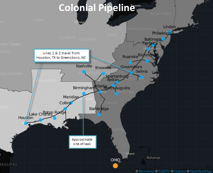
Colonial Pipeline Leak.
- Thread starter hatt
- Start date
- Status
- Not open for further replies.
Patman
Staff member
Gas prices in Toronto went up 2 cents per liter overnight and are forecasted to go up another 5 cents per liter in the next few days because of that leak, so they are already taking advantage of the consumers up here.

gas price up two cents per gallon since yesterday 9/16
Quote:
Still, the pipeline is the "largest artery" supplying gasoline in several Southeast states, DeHaan said. Storage sites are quickly depleting pent-up supplies to fulfill demand.
So these "gasoiline" pipelines are the reason why the Southeast usually have the cheapest gas prices in the nation? I'm asking because here in the Mid West we have our own refineries, hiring local workers, and only ship in crude and natural gas.
Last edited:
Not completely accurate - see the network of blue colored lines on this map, including the Midwest, showing US refined products pipelines.
http://www.api.org/oil-and-natural-gas/w...l-and-pipelines
See how many flow northward from the USGC?
http://www.api.org/oil-and-natural-gas/w...l-and-pipelines
See how many flow northward from the USGC?
Last edited:
Plantation Pipeline - Colonial's major competitor.
http://www.kindermorgan.com/content/docs/ppl_system_map.pdf
http://www.kindermorgan.com/content/docs/ppl_system_map.pdf
I wish it was up only $0.03 in NW Indiana -- more like $0.30/gallon.
Nope the wife made a huge batch of beans.. should have enough gas to bike all week without running out

Originally Posted By: Nyogtha
Not completely accurate - see the network of blue colored lines on this map, including the Midwest, showing US refined products pipelines.
http://www.api.org/oil-and-natural-gas/w...l-and-pipelines
See how many flow northward from the USGC?
The blue colored lines are natural gas. It has always flowed from the gulf, at less than 60% capacity, Trunkline even abandoned a 30" line to convert to a petroleum line.(complements the Keystone pipeline, or to get around the politics, it is under the radar) The big cluster east of St. Louis is the Patoka Tank Farm, the southern "red" line is the old "Capline System" it does flow north, however, they want to reverse flow(Canadian Oil) but a small shareholder(BP) refinery cannot use the Canadian type crude. It is running at 30% of capacity.
Canadian crude wants to flow south, and monsters like Energy Transfer and the Dakota Access Pipeline is putting pressure to reverse flows.
Last edited:
Two gas stations I went to in the Greensboro/High Point, NC area are out of gas. I was lucky to purchase some E0 gas that was left over. Filled up both my cars and extra 20 gallons of gas in containers. The manager in the store said it might be another week before gas come back.
Originally Posted By: Vern_in_IL
Originally Posted By: Nyogtha
Not completely accurate - see the network of blue colored lines on this map, including the Midwest, showing US refined products pipelines.
http://www.api.org/oil-and-natural-gas/w...l-and-pipelines
See how many flow northward from the USGC?
The blue colored lines are natural gas. It has always flowed from the gulf, at less than 60% capacity, Trunkline even abandoned a 30" line to convert to a petroleum line.(complements the Keystone pipeline, or to get around the politics, it is under the radar) The big cluster east of St. Louis is the Patoka Tank Farm, the southern "red" line is the old "Capline System" it does flow north, however, they want to reverse flow(Canadian Oil) but a small shareholder(BP) refinery cannot use the Canadian type crude. It is running at 30% of capacity.
Canadian crude wants to flow south, and monsters like Energy Transfer and the Dakota Access Pipeline is putting pressure to reverse flows.
You must be looking at a map different than the one I linked as the legend in the lower right hand corner of the map at the link I posted clearly shows the blue lines as refined product pipelines.
Try looking again.
You may find this educational also Vern.
http://www.refinerlink.com/blog/us_padd_overview/
PADD II, the Midwest, contains only 21% of the nation's refining capacity. Many (most) of the domestic refinery permanent shutdowns in the last 2 decades have been in the Midwest.
I've directly worked at multiple refineries in PADD III (USGC) and PADD II (Midwest).
Here's a note about the Explorer pipeline, now coming up on its 45th anniversary.
Explorer Pipeline 40th Anniversary
Last edited:
Went up a few cents. Just filled up at Sams club zero problems.
I wonder how bad water contamination will be from this cas spill ?
Gas stations here are starting to run out however I have not seen any gas lines yet and many stations still have gas. I think people are used to not panicking from previous gas shortages and are only filling up only when they actually need to. They are saying things will be back to normal in a few days since the pipeline bypass is in operation.
Originally Posted By: Mr Nice
I wonder how bad water contamination will be from this cas spill ?
Originally Posted By: John_Conrad
from the article:
"State workers discovered the leak when they noticed a strong gasoline odor and sheen on a man-made retention pond, along with dead vegetation nearby, the Pipeline and Hazardous Materials Safety Administration said in the report."
"From an ecological standpoint, the spill couldn't have happened at a better place or time because the terrain funneled the fuel into the pond and the water was low enough in the small lake to enable it to hold the gas, said Butler, of Cahaba Riverkeeper."
See this thread
https://bobistheoilguy.com/forums/ubbthreads.php/topics/4207253/1
- Status
- Not open for further replies.
Similar threads
- Replies
- 10
- Views
- 453
- Replies
- 15
- Views
- 713